The Route 28 Corridor Project
Nearly three miles of state road work, strip land takings along the way — and a zoning change riding with it that needs your Town Meeting vote.
A Yarmouth local issue — researched from MassDOT and Town of Yarmouth records, linked at the bottom. There is real good in this project. There are also real consequences for property owners and for what the corridor becomes — and those deserve daylight before the decisions are final.
What the project is
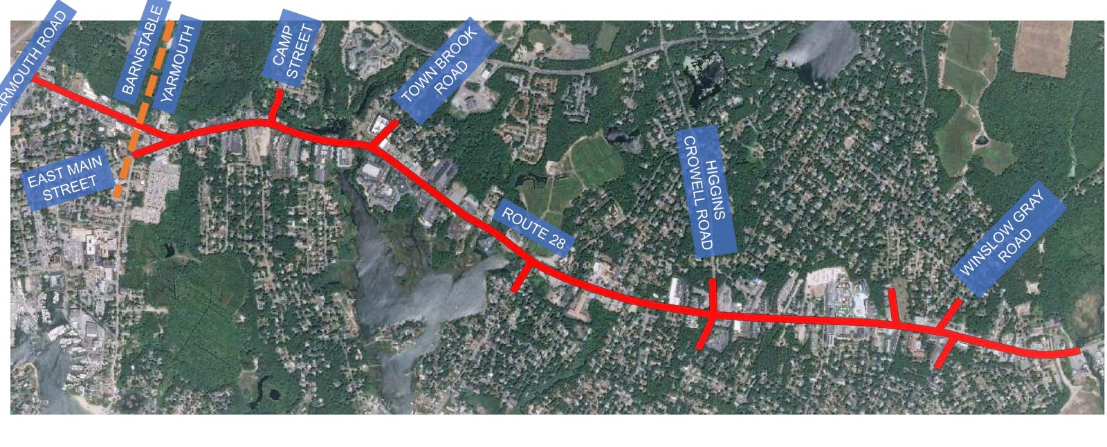
MassDOT Project #608264 covers about 2.9 miles of Route 28 — from Yarmouth Road in Hyannis to the Parkers River in Yarmouth, plus short stretches of the side streets. Its stated goals: safety, better intersections, and travel for more than just cars — the design includes a 10-foot shared-use path for bikes and pedestrians. The state held its 25% Design Public Hearing in November 2023; the Town posts the concept plans, including a widened path option and a two-lane concept near Town Brook.
The part fewer people know: land takings
To fit the sidewalks, path, and safety improvements, the state will take strips of land of varying widths from some properties along Route 28. That is not our characterization — it is the Town’s own explanation, in writing, in the Planning Board’s February 2026 materials. If you own property on the corridor, the width of the strip in front of your parcel is drawn on the design plans — and the time to look is before the right-of-way process reaches your mailbox.
The zoning that rides along
Yarmouth’s Route 28 overlay zoning (the VCOD) actually requires buildings in its village centers to sit close to the road — a maximum front setback, to create a village feel. The state’s takings would push some existing and planned buildings out of compliance with the Town’s own rule. So the Town has drafted a zoning article letting VCOD projects get setback relief by Special Permit instead of Variance — a meaningfully easier path. Reasonable fix or another notch of flexibility for corridor development, it is a Town Meeting decision requiring a two-thirds vote. That means the people in the room decide — and you can be one of them.
Why this matters beyond the pavement
The road project, the zoning flexibility, and the arrival of sewer are moving together — and together they are the engine remaking the corridor. To see what the finished product looks like, read our companion page on 228 Route 28: a fully approved retail-plus-apartments building produced by exactly this zoning. The corridor project is not just about sidewalks. It is the frame the next twenty years of Route 28 gets built inside.
What residents can do
- Corridor property owners: pull the design plans (linked below) and find your frontage. Ask the Town or MassDOT what is drawn in front of your parcel.
- Go to Town Meeting. The setback article — and every zoning change that follows the corridor project — needs a 2/3 vote from the floor. Zoning is one of the few places where your presence literally is the decision.
- Stay informed: the YRTC is tracking the design milestones, the takings, and the zoning articles. Email info@yarmouthrtc.com to get on the list.
Sources
- MassDOT 25% Design Public Hearing notice, Nov. 21, 2023 (Project #608264)
- Town of Yarmouth — Route 28 Corridor Improvements (concept plans + 11/21/23 presentation)
- Planning Board packet, Feb. 4, 2026 (land-takings language + draft VCOD setback article)
- Town of Yarmouth — Village Centers Overlay District
Paid for by the Yarmouth Republican Town Committee.
Want to know when things like this happen in Yarmouth? Sign up for local issue alerts →Forest Road, the housing authority, zoning — just the alerts, nothing more.